
Mesozoic and Cenozoic Paleocontinental Maps

Mesozoic and Cenozoic Paleocontinental Maps
$46.99
USDFirst published in 1977, this book shows the positions of the major continental areas during the past 220 million years as four series of computer-drawn maps. The maps have been drawn for the present day, 10 and 20 million years ago, then at 20-million-year intervals back to 220 million years. All the maps are based on quantitative geophysical or topographic information: paleomagnetic pole positions, ocean floor magnetic anomalies, and best fits of the continental margins. Mercator, north polar and south polar sterographic, and Lambert equal-area maps of each selected time interval are provided. Many interesting problems in the Earth Sciences are global; they need to be seen in a proper global setting. The maps provide such a framework on which a very wide range of geological information may be plotted. Problems in fields as widely separated as palenontology, stratigraphy, geochemistry and tectonics may usefully be displayed on these maps.
Product details
June 1977Paperback
9780521291170
64 pages
246 × 189 × 3 mm
0.13kg
Available
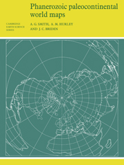


Table of Contents
- Introduction
- 1. Method of making the maps
- 2. Projections: i. Mercator's projection
- ii. Stereographic projection
- iii. Lambert's equal-area projection
- 3. Reliability of the maps
- 4. Final remarks
- Acknowledgements
- Bibliography
- The maps.