
Rome's World
Rome's World
$41.99
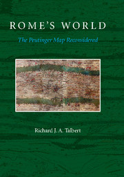
USDThe Peutinger Map is the only map of the Roman world to come down to us from antiquity. An elongated masterpiece, full of colorful detail and featuring land routes across Europe, North Africa, and the Near East, it was rediscovered mysteriously around 1500 and then came into the ownership of Konrad Peutinger, for whom it is named. Today it is among the treasures of the Austrian National Library in Vienna. Richard Talbert’s study presented in Rome’s World: The Peutinger Map Reconsidered offers a long-overdue reinterpretation and appreciation of the map as a masterpiece of both mapmaking and imperial Roman ideology. Here, the ancient world’s traditional span, from the Atlantic to India, is dramatically remolded; lands and routes take pride of place, whereas seas are compressed. Talbert posits that the map’s true purpose was not to assist travelers along Rome’s highways, but rather to celebrate the restoration of peace and order by Diocletian’s Tetrarchy. Such creative cartography, he shows, influenced the development of medieval mapmaking. With the aid of an interactive database, this book enables readers to engage with the Peutinger Map in all of its fascinating immensity more closely than ever before.
- A major advance in our understanding of how maps were made in antiquity
- An unprecedented appreciation of how cartography contributed to the promotion of Roman imperial ideology
- Uses digital technology to present and analyze this immense, unwieldy Roman map in ways that no print product could achieve
Reviews & endorsements
"With his unquestionably fresh or rather, in Talbert’s own words "radical, not to say provocative" interpretation (p. 7), the author succeeds in showing that the Peutinger map indeed represents much more than a "mere route diagram" … it is a very rich, detailed and inspiring study. In combination with the supporting online materials, it will undoubtedly stimulate further research on and debate about the Peutinger map."
Bryn Mawr Classical Review
"The great strength of Talbert’s book is that it argues - at times almost despite itself - for an imaginative non-cartographical viewing of the Peutinger Table."
The Times Literary Supplement
"One of the finest and most complete and most accessible collections of historical GIS data that I’ve ever seen."
Digital Humanities Specialist
"… deserves our gratitude for having made the TP [Peutinger Map] digitally accessible to the scholarly community and for having provided a detailed commentary."
Bulletin of the American Society of Papyrologists
Product details
May 2014Paperback
9781107685758
256 pages
253 × 178 × 24 mm
0.79kg
33 b/w illus. 1 table
Available


.jpg)
.jpg)
Table of Contents
- Introduction
- 1. The surviving copy: history, publication, scholarship
- 2. The surviving copy: the material object and its palaeography
- 3. Design and character of the map
- 4. Recovery of the original map from the surviving copy
- 5. The original map
- Conclusion: the map's place in classical and medieval cartography.